Showing posts with label inspiring walks. Show all posts

Tuesday, July 26, 2016

Blessington Greenway


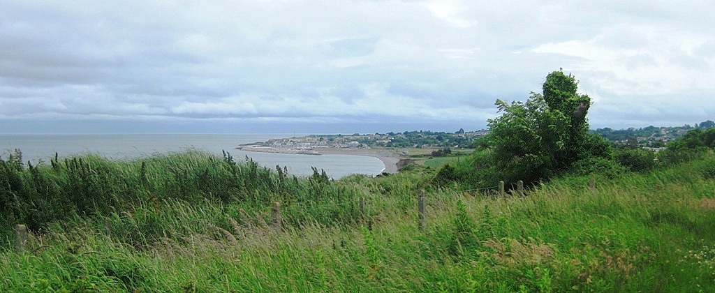
view of one of the lakes along Blessington Greenway, own photo
Blessington Greenway walk provides an easy escape from the city with a 7k stomp through the countryside that is easily reached by public transport. The walkway, which opened as recently as 2014, is fully accessible by car or bus. The 65 goes from Dublin city centre almost to the start of the walk at the Northern tip of Blessington in Wicklow. Even if you decide to stop in Blessington town centre for refreshment first, it's only a stone's throw to AvonRi resort and adventure centre,  where the greenway begins. Access is through a gate in the back car park.

Blessington Greenway, photo by Sheila Mahon
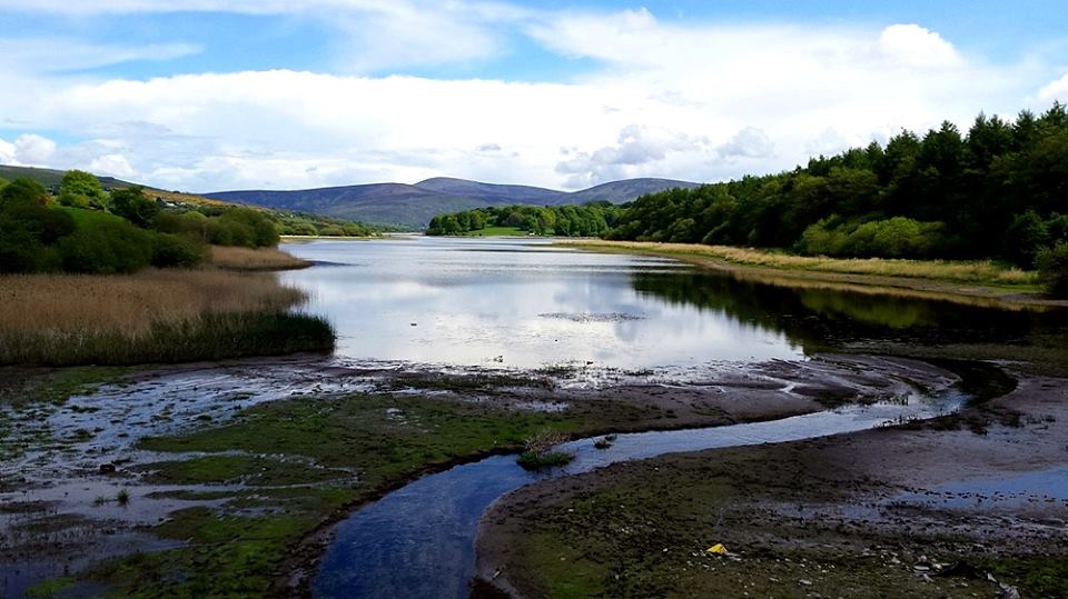
Although the route commences so close to the town, you are instantly distanced from civilisation. The path takes you round the side of the lake and through the forest. After a while, however , you do need to leave the woods and follow the road for a few metres before resuming the track once more.  
view looking back from lake, own photo
photo by Sheila Mahon
Several kilometres on, you will need to emerge again and cross a road but at no point do you have to walk on unsafe road or on any grass verge, except at the end, when turning up a short, quiet road that leads to Russborough House. For this reason, I give this route the thumbs up for safety as well as accessibility. It is also level, with no hills to negotiate and the path is easy underfoot. At some points boardwalks help the walker cross what would be boggy or uneven terrain. I have done this walk in light rain with no bother.
Russborough House, Photo by Sheila Mahon
Russborough House is worth a tour if you have the time and interest, but at the very least the quaint tearooms serve up seriously good cake and a chance to rest. There are also a few craft studios in the beautiful grounds and a maze, which I have yet to explore. The first time trying out this walk, after a decent lunch, we braved the whole walk back to Blessington. However, 14k can be a bit much in one day, even for an avid walker like me. Revisiting with a bunch of friends on a muggy day last weekend, we left one car in Russborough and another at the start of the walk. We were so grateful for our foresight. There is a bus stop near Russborough but the route isn't all that frequent so be advised to check bus times both in advance and on Dublin Bus's real time app if possible. 

Apart from the ease and accessibility of this walk, I love it because it takes you through a variety of scenery. With cake at the end, what's not to love?


Tuesday, July 5, 2016

Pigeon House towers & Poolbeg lighthouse- Caught My Eye 37

Caught My Eye  is a series of blog posts showing scenes I found interesting, odd, curious or beautiful. Some curiosities that I capture inspire the Jewellery that I make. Others don't, but just getting out there and looking fires up the imagination. I am a creative observer, not  a  photographer  by any  description.  So  if  you  expect  top  quality  photography I'm afraid you will be disappointed.  Please simply enjoy a snap-shot glimpse of the world and maybe grab some inspiration for yourself.
Pigeon House chimneys, Poolbeg up close, own photo 2015

Here is a sight that's as Dublin as Guinness, the Liffey and the traders on Moore Street are. 
Dubliners have used the Pigeon House power station chimneys  in Poolbeg  as a point of  reference from afar ever since 1903.  Whether you are viewing the  unmistakable towers from another  point along Dublin bay such as Dollymount or Dun Laoghaire or from up the Dublin mountainsthey are a well known landmark in the distance that helps get your bearings. 


I only noticed this week that I can even see them from Portobello on the edges of the city centre. I have been looking at them daily on the way to work for a few years now and never even noticed. They were just there, part of the accepted skyline.


Poolbeg chimneys from Dollymount, own photo, 2013
This shot was taken from the bathing area at Dollymount strand in the north of the city. (Caught my Eye #16)


Here is the view from the south, taken at Monkstown, near Dun Laoghaire. 
Pigeon House chimneys, own photo, 2015

This is a shot from another location along the same stretch of shore. Is that Jaws lurking in our waters?
Poolbeg chimneys, Dublin, own photo 2015
The closest view is via a path running between Sandymount strand and Irishtown park which takes you behind the disused power station, around to the docks and the jetty leading  to Poolbeg lighthouse. (See it here on Map my Walk but do come back to me here!) If you've never done this walk, be forewarned that it's a rather fragrant part of the city with the waste water treatment plant right beside the towers. After a while you don't notice the...um...aroma anymore, though I cracked up when my  friend told me she was taken there on a school trip back in her school days. Now there is a teacher with a sense of humour!


Poolbeg pier, own photo, 2015
The red dot at the end of the angled pier is Poolbeg lighthouse, a part of the city that can feel strangely remote. Dublin is full of surprises and inspiration. For about two seconds I considered using the red and white chimneys of Poolbeg as inspiration for dangly earrings. Then sanity returned. They do however, remind me of candy cane ornaments. I'm off to to play around with some designs....


Tuesday, July 2, 2013

Greystones to Bray Cliff Path

 On Friday last I walked the Greystones to Bray cliff path for the first time in a year. This is a highly accessible route by public transport and only requires a reasonable level of fitness - ie you need to be ok to walk for about 90 minutes to 2 hours and there are a couple of sets of steps in the middle which are quite deep and not kind to dodgy knees. It is mostly flat, with a low gradient slope at each end. The walk is approximately 7k but if you are travelling by DART there is a little extra walking at each end. The train takes under an hour from Dublin city centre and 40 mins back from Bray.
 

Many consider it the Bray to Greystones path, but I prefer to start in Greystones, further South, for a number of reasons.  Walking northwards means the sun isn't in your face. More importantly, the DART (Dublin coastal & city centre train) back to the city is more frequent from Bray so I don't even bother checking train times home in the early evening, whereas from Greystones you are better off knowing when to turn up at the station. The path is closer to the coast at Bray so the view as you finish is much more breathtaking. Lastly, you have a greater choice of watering holes and eateries close together on the bustling seafront at Bray. (One of these days I will do Bray to Greystones and back again!!)

part of the new harbour at Greystones, June 2013 (own photo)
My friends and I like to take a little detour at the start of this walk, turning left (South) outside the dart station in Greystones instead of right, grabbing a coffee to go and walking a few yards to the beach for a quick picnic. Then we walk back along the beach and ascend some steps at the North end of the strand onto a paved coastal walk that takes you to the new harbour and marina, which seems to be almost finished now.


Keep following the natural line of the pavement (sidewalk) as it curves to the left until you are directly across the road from a pub and to your right you will catch the new access to the cliff path, running alongside a fish n chip cafe.  This is a new start since last year and very even underfoot. The beginning of the route has a fence on one side and doesn't yet afford a clear view of the sea for several minutes. However at this time of year at least, the pathway is a riot of colour, lined with pink, red and yellow wildflowers. I made a mental note to check if I have beads or buttons to match these hues so I can use them as inspiration for some summer jewellery.
path to the cliffs at Greytones (own photo)

looking back at Greystones, a short way into the hike
Shortly, the path opens out into lush green land with a view of the low hill, Bray Head, straight ahead of you. Look behind you and you can catch a glimpse of Greystones strand. The way gets gradually steeper as it winds higher towards the side of the cliff. At some points the path narrows and is lined with nettles and brambles, so shorts are not a great idea!


this photo was taken in early 2012,the first time I did this walk
July 2013

Eventually you reach the cliff side with refreshing views of the open sea and the winding rail track below. This older section of path is still fairly even, though some parts are narrower and rockier.  At no point are you teetering at the cliff edge as you are at points in Howth, at the other end of the same DART line. (Future post yet to come.)

(own photo)
View looking backwards or what you see from the Bray side (own photo)
tunnel eyes (0wn photo)
My favourite section is when the path turns a corner and you see the tunnel 'eyes' watching you. The outer train tunnel is the original one but the track was moved a little more inland following an accident in 1869. Read  more about these tunnels in my previous post HERE.

Closer to Bray there are a couple of exits off and upwards where you can gain access to Bray Head if you want  a steeper challenge and a longer walk. This hill is not very high, but many find it very steep, especially on the way down. (I bent back and broke a toenail rather painfully on the way down last year and chickened out of climbing it again.) The cliff path ends up next to the Bray access and car park for the the hill walk and the road winds down to the seafront where you can find refreshments.
View of Bray from the top of Bray Head (own photo) 2012
It took us a little over 2 hours from when we landed on the beach with a couple of pit stops for a quick bite to eat and several photo stops. Walking at an easy pace without lunch stops should take perhaps 90 minutes. If you are driving, you can park at Greystones Harbour or Bray seafront and take the Dart back to your starting point.

Now I'm off to find some beads to match those flowers......


Monday, May 13, 2013

Inspirations. Dollymount Strand

Lately I've been very lacking in creative inspiration and I put it down to the fact that I've been unable to walk much on my foot since plantar fasciitis struck last Autumn. However, I've slowly been able to get back into my walking boots with a combination of physio and other means.

So I decided to brave it and go for a decent walk with my Etsy friend, Mo of Huggleknits, and combine it with a catch up about Etsy business.  We chose to revisit a Dublin city beach I hadn't been to in almost a decade, Dollymount Strand, just North of the city centre. It is much closer than I'd ever realised and it is easily accessible by bus.
Abbey Street Lower, Dublin, Co. Dublin
Catch the bus on Lower Abbey Street. (Dublin, Google Maps)
Take the 130 bus from Lwr Abbey St. The fare is currently €2.40 and in bad, Saturday afternoon traffic it took about 30 mins. Coming back around 7pm took just 2o mins. Once past Fairview, the Clontarf road affords beautiful views of Dublin Bay and Harbour. There is a coastal promenade in Clontarf which is popular with walkers all year round. It stretches from Fairview Park to the Bull wall at Dollymount so alternatively, you could get off at any point and follow this paved walkway.
Dollymount bridge, May 2013, Amo'r
However, the busstop for Dollymount strand is immediately after the landmark wooden bridge. The bridge takes you to North Bull island and its sandy beach. Cars use the bridge to access the car park, but there is a wide pedestrian section on both sides so it is perfectly safe for walkers. 
 
The island is a relatively new land formation that grew from a small sand bank over the past 200 years. The South Wall and the Bull Wall were built to stop silting in the Liffey and as a result, tidal currents deposited layer upon layer of sand creating this unusual sanctuary so close to the hustle and bustle of the city centre.

Dollymount strand  Looking Northwards to Howth, May 2013, Amo'r
The flat, sandy beach stretches about 5km (over 3 miles) long and affords a comfortable, scenic walk at any time of year, with breathtaking, expansive views of Dublin bay.  You can see ships entering and leaving Dublin Docks just to the South. Beyond the curve of coastline, the Wicklow mountains are clearly visible on the horizon. To the North you can see the Sutton side of the Howth peninsula.

When I was a kid we used to go to Dollymount strand for walks in Winter and Spring. We never swam in the sea as, if my memory serves me well, it was not the cleanest of beaches then. Today it is super clean and known for its ecological uniqueness.  The island is a UNESCO biosphere reserve boasting a bird and wild life sanctuary at the Northern end.  There is plenty of space to walk, run, fly a kite or just chill.
The fresh air did the trick and I've got a number of design ideas floating in my head (if you'll excuse the unintended pun please.)


For more inspiring walks around or close to Dublin, click HERE
To catch a glimpse of a curious bathing area at Dollymount click HERE

Some sea pottery, sea glass and sea themed items from my Etsy store:

Brown Sea Pottery Pendant. Irish Beach Pottery Necklace on Crochet Chain. Storm in a Teacup  Irish Beach Glass & Copper Pendant or Ornament. Stirring Sea 
 Labradorite Pendant. Starfish. Sterlng Silver Star Fish & Gemstone Pendant. Sea Maiden Seaglass Fairy Suncatcher, Christmas Ornament, Rear View Mirror Charm or Pendant
Irish Keychain. Seaglass from Ireland. Vintage Teal Beach Glass Keychain  Irish Sea Pottery Pendant or Charm. Wire Wrapped Sea Porcelain. Ocean Blue